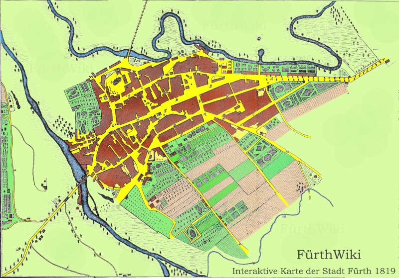
Widget:Karte 1819
Zur Navigation springen
Zur Suche springen
<html>
<body>
FürthWiki: Interaktive Karte der Stadt Fürth von 1819
<img src="https://maps.fuerthwiki.de/map1819/Fuerth_1819k.jpg" width="800" height="559" border="0"
           alt="Karte" usemap="#Landkarte">
     <map name="Landkarte">
       <area shape="circle" coords="234,162,10"
              href="http://fuerthwiki.de/wiki/index.php/Kirche_St._Michael" alt="Kirche St. Michael" title="Kirche St. Michael">
       <area shape="poly" coords="244,152,248,150,255,166,250,169,244,152"
              href="http://fuerthwiki.de/wiki/index.php/Pfarrhaus_St._Michael" alt="Pfarrhaus St. Michael" title="Pfarrhaus St. Michael">
       <area shape="poly" coords="211,264,234,251,231,221,222,215,225,245,211,264"
              href="http://fuerthwiki.de/wiki/index.php/Marktplatz" alt="Marktplatz" title="Marktplatz (Grüner Markt)">
       <area shape="poly" coords="184, 330, 192, 322, 201, 293, 209, 276, 213, 269, 210, 263, 194, 287, 187, 310, 184, 330"
              href="http://fuerthwiki.de/wiki/index.php/Königstraße" alt="Untere Frankfurter Straße" title="Untere Frankfurter Straße (Untere Köngistr.)">
       <area shape="poly" coords="241,257,298,236,294,231,239,250,241,257"
              href="http://fuerthwiki.de/wiki/index.php/Königstraße" alt="Rosengasse" title="Rosengasse (heute Teil der Königstr.)">
       <area shape="poly" coords="305, 297, 318, 295, 336, 318, 325, 325, 291, 323, 298, 297"
              href="http://fuerthwiki.de/wiki/index.php/Fraveliershof" alt="Fraveliershof" title="Bei dem Frau von Liershof (Fraveliershof)">
       <area shape="poly" coords="231, 204, 329, 150, 331, 155, 240, 209, 231, 204"
              href="http://fuerthwiki.de/wiki/index.php/Gustavstraße" alt="Bauernstraße" title="Bauernstraße (heute Gustavstraße)">
       <area shape="poly" coords="260,274,266,272,271,279,265,284,260,274"
              href="http://fuerthwiki.de/wiki/index.php/Synagoge" alt="Synagoge" title="Jüdische Synagoge">
       <area shape="poly" coords="428,424,434,420,442,431,484,402,496,420,452,454,428,424"
              href="http://fuerthwiki.de/wiki/index.php/Lochnersches_Gartenhaus" alt="Pfarrgarten" title="Lochnerscher Pfarrgarten">
       <area shape="poly" coords="320,295,323,293,347,326,386,370,408,393,427,424,490,496,483,499,402,391,319,295,320,295"
              href="http://fuerthwiki.de/wiki/index.php/Theaterstraße" alt="Theaterstrasse" title="Fußweg nach Dambach (heute Theaterstraße)">
       <area shape="poly" coords="411,552,415,508,433,501,492,525,511,509,519,470,563,425,613,377,681,398,657,433,514,555,411,552"
              href="http://fuerthwiki.de/wiki/index.php/Leyher_Landgraben" alt="Leyher Landgraben" title="Leyher Landgraben">
       <area shape="poly" coords="471,192,492,184,503,213,486,224,471,192"
              href="http://fuerthwiki.de/wiki/index.php/Brauerei_Lederer" alt="Brauerei Lederer" title="Brauerei Lederer (spätere Brauerei Geismann)">
       <area shape="poly" coords="503,176,518,171,518,161,494,158,503,176"
              href="http://fuerthwiki.de/wiki/index.php/Brauerei_Mailänder" alt="Brauerei Mailaender" title="Brauerei Mailänder">
       <area shape="poly" coords="505,180,514,177,514,181,530,176,540,197,518,208,505,180"
              href="http://fuerthwiki.de/wiki/index.php/Brauerei_Humbser" alt="Brauerei Humbser" title="Brauerei Humbser">
       <area shape="poly" coords="260,115,298,1,290,1,249,118"
              href="http://fuerthwiki.de/wiki/index.php/Ludwigsbrücke" alt="Poppenreuther Bruecke" title="Poppenreuther Brücke (heute Ludwigsbrücke)">
       <area shape="poly" coords="401,226,410,223,432,232,411,248,401,226"
              href="http://fuerthwiki.de/wiki/index.php/Kohlenmarkt" alt="Kohlenmarkt" title="Kohlenmarkt">
       <area shape="poly" coords="429,235,512,270,515,260,435,231,429,235"
              href="http://fuerthwiki.de/wiki/index.php/Schwabacher_Straße" alt="Schwabacher Strasse" title="Schwabacher Straße">
       <area shape="poly" coords="154,373,176,347,179,352,156,377,154,373"
              href="http://fuerthwiki.de/wiki/index.php/Maxbrücke" alt="Untere Bruecke" title="Untere Brücke (heute Maxbrücke)">
       <area shape="poly" coords="155,411,164,410,161,374,156,376,155,411"
              href="http://fuerthwiki.de/wiki/index.php/Foerstermühle" alt="Foerstermühle" title="Foerstermühle">
       <area shape="poly" coords="388,97,391,87,401,89,418,102,415,109,388,97"
              href="http://fuerthwiki.de/wiki/index.php/Wolfsgrubermühle" alt="Wolfsgrubermuehle" title="Wolfsgrubermühle">
       <area shape="poly" coords="713,147,758,119,715,67,682,114,713,147"
              href="http://fuerthwiki.de/wiki/index.php/Friedhof" alt="Neuer Kirchhof" title="Neuer Kirchhof (Friedhof)">
       <area shape="poly" coords="239, 409, 253, 405, 261, 396, 259, 388, 271, 373, 294, 416, 305, 424, 315, 424, 347, 446, 334, 479, 239, 409"
              href="http://fuerthwiki.de/wiki/index.php/Jüdischer_Friedhof" alt="Juedischer Friedhof" title="Jüdischer Friedhof">
       <area shape="poly" coords="536, 167, 560, 162, 701, 163, 700, 155, 524, 150, 527, 161"
              href="http://fuerthwiki.de/wiki/index.php/Nürnberger_Straße" alt="Nuernberger Straße" title="Nürnberger Straße">
       <area shape="circle" coords="90,371,12"
              href="http://fuerthwiki.de/wiki/index.php/Kapelle_St._Martin" alt="Ruine St. Martin" title="Ruine der Kirche St. Martin">
       <area shape="circle" coords="136,266,10"
              href="http://fuerthwiki.de/wiki/index.php/Schießhaus" alt="Schiesshaus" title="Schießhaus">
       <area shape="circle" coords="195,419,10"
              href="http://fuerthwiki.de/wiki/index.php/Schleuse" alt="Schleusse" title="Schleuße">
       <area shape="circle" coords="296, 218, 12"
              href="http://fuerthwiki.de/wiki/index.php/Rotes_Roß" alt="Rotes Ross" title="Rößleinswirthshof (Wirtshof Rotes Ross)">
       <area shape="circle" coords="376,154,10"
              href="http://fuerthwiki.de/wiki/index.php/Feuerwehr" alt="Feuerwehr" title="Feuerwehrgerätehaus">
       <area shape="circle" coords="383,202,14"
              href="http://fuerthwiki.de/wiki/index.php/Brandenburgisches_Haus" alt="Brandenburgisches Haus" title="Brandenburgisches Haus (später Rathaus)">
       <area shape="poly" coords="316,214,337,202,345,228,330,234,316,214"
              href="http://fuerthwiki.de/wiki/index.php/Obstmarkt" alt="Holzmarkt" title="Holzmarkt (heute Obstmarkt)">
       <area shape="poly" coords="337,201,342,212,461,164,450,157,337,201"
              href="http://fuerthwiki.de/wiki/index.php/Königstraße" alt="Obere Frankfurter Str" title="Obere Frankfurter Straße (heute Königstraße)">
       <area shape="poly" coords="471,249,544,204,549,209,481,251,471,249"
              href="http://fuerthwiki.de/wiki/index.php/Alexanderstraße" alt="Alexanderstrasse" title="Alexanderstraße">

       <area shape="poly"
coords="250,110,259,99,230,103,213,93,193,94,175,105,159,108,144,91,146,75,149,60,140,41,132,35,113,25,100,0,94,0,102,19,107,29,125,38,136,47,142,56,138,79,140,101,151,112,165,116,186,107,202,99,219,102,233,111,243,112"
              href="http://fuerthwiki.de/wiki/index.php/Pegnitz" alt="Pegnitz" title="Pegnitz">
       <area shape="poly" coords="264,101,260,113,282,119,314,125,338,120,345,111,341,103,327,98,315,96,312,86,313,79,329,69,329,56,327,40,338,31,352,36,359,51,362,77,368,88,383,90,392,86,400,87,419,102,445,107,452,116,480,124,532,130,545,129,582,129,612,126,634,133,656,140,672,141,684,133,687,120,676,108,667,101,659,94,630,81,592,69,587,61,587,46,597,39,623,35,639,34,647,25,655,14,667,12,672,0,666,0,659,9,649,14,639,28,622,31,593,34,582,44,580,63,589,75,620,83,650,98,667,109,677,120,677,129,668,134,642,130,613,121,560,123,552,126,548,124,528,124,525,120,525,114,530,103,526,98,518,100,515,110,521,114,519,123,468,115,450,103,444,99,425,97,400,79,379,82,369,74,363,40,355,29,341,24,324,32,320,46,323,61,309,76,302,87,310,102,335,105,335,113,307,119,280,108,264,101"
              href="http://fuerthwiki.de/wiki/index.php/Pegnitz" alt="Pegnitz" title="Pegnitz">
<area shape="poly"
coords="173,361,160,373,169,430,192,446,212,458,229,477,245,488,302,513,314,522,322,532,329,533,317,520,347,533,359,533,326,514,310,508,300,508,288,502,265,489,237,474,226,461,219,454,202,439,181,424,175,411,175,396,175,379,173,361"
              href="http://fuerthwiki.de/wiki/index.php/Rednitz" alt="Rednitz" title="Rednitz">
       <area shape="poly"
coords="0,59,10,88,43,131,50,145,54,158,55,176,60,196,74,205,85,235,100,260,140,294,138,305,173,349,172,354,157,368,146,353,145,341,117,290,93,264,86,248,55,201,42,141,13,104,0,84,0,59"
href="http://fuerthwiki.de/wiki/index.php/Rednitz" alt="Rednitz" title="Rednitz">
       <area shape="poly" coords="407,211,511,177,511,174,404,207,407,211"
             href="http://fuerthwiki.de/wiki/index.php/Bäumenstraße" alt="Neue Gasse" title="Neue Gasse (heute Bäumenstraße)">
       <area shape="poly" coords="151, 294, 178, 281, 201, 273, 186, 287, 153, 306" href="https://www.fuerthwiki.de/wiki/index.php?title=Wilhelm-Löhe-Straße" alt="Schrotgasse" title="Schrotgasse (heute Wilhelm-Löhe-Straße)">
       <area shape="poly" coords="186, 162, 197, 159, 224, 204, 218, 209, 208, 188" href="https://www.fuerthwiki.de/wiki/index.php?title=Heiligengasse" alt="Heiligengasse" title="Heiligengasse (heute Heiligenstraße)">
       <area shape="poly" coords="268, 145, 279, 144, 283, 153, 287, 166, 278, 169" href="https://www.fuerthwiki.de/wiki/index.php?title=Obere_Fischerstraße" alt="Fischergasse" title="Fischergasse (heute Obere Fischerstraße)">
       <area shape="poly" coords="388, 140, 409, 141, 421, 144, 419, 152, 390, 150" href="https://www.fuerthwiki.de/wiki/index.php?title=Helmstraße" alt="Helmplattengäßlein" title="Helmplattengäßlein (heute Helmstraße)">
       <area shape="poly" coords="438, 125, 446, 126, 447, 134, 447, 141, 435, 141" href="https://www.fuerthwiki.de/wiki/index.php?title=Helmplatz" alt="Helmplatte" title="Helmplatte (heute Helmplatz)">
       <area shape="poly" coords="355, 221, 375, 222, 386, 228, 386, 237, 354, 231" href="https://www.fuerthwiki.de/wiki/index.php?title=Ludwig-Erhard-Straße" alt="Sternbeckengasse" title="Sternbeckengasse (heute Ludwig-Erhard-Straße)">
       <area shape="poly" coords="317, 264, 348, 246, 368, 238, 379, 244, 321, 273" href="https://www.fuerthwiki.de/wiki/index.php?title=Wasserstraße" alt="Vordere Wassergasse" title="Vordere Wassergasse (heute Wasserstraße)">
       <area shape="poly" coords="325, 282, 368, 262, 402, 244, 401, 253, 336, 289" href="https://www.fuerthwiki.de/wiki/index.php?title=Gartenstraße" alt="Hintere Wassergasse" title="Hintere Wassergasse (heute Gartenstraße)">
       <area shape="poly" coords="304, 248, 310, 241, 325, 235, 320, 247, 312, 253" href="https://www.fuerthwiki.de/wiki/index.php?title=Mohrenstraße" alt="Hinter dem Realschulgebäude" title="Hinter dem Realschulgebäude (heute Mohrenstraße)">
       <area shape="poly" coords="228, 309, 224, 298, 238, 309, 260, 315, 241, 329" href="https://www.fuerthwiki.de/wiki/index.php?title=Markgrafengasse" alt="Markgräfische Gasse" title="Markgräfische Gasse">
       <area shape="poly" coords="187, 341, 215, 311, 233, 337, 214, 349, 198, 354" href="https://www.fuerthwiki.de/wiki/index.php?title=Gänsberg" alt="Gängenberg" title="Gängenberg (Gänsberg)">
       <area shape="poly" coords="198, 362, 227, 372, 247, 374, 235, 384, 211, 379" href="https://www.fuerthwiki.de/wiki/index.php?title=Rednitzstraße" alt="Schindergasse" title="Schindergasse (Rednitzstraße)">
       <area shape="poly" coords="281, 356, 291, 351, 294, 363, 287, 380, 278, 374" href="https://www.fuerthwiki.de/wiki/index.php?title=Schlehengasse" alt="Schlehengasse" title="Schlehengasse (heute Schlehenstraße)">
       <area shape="circle" coords="337, 186, 10" href="https://www.fuerthwiki.de/wiki/index.php?title=Schindelgasse" alt="Schindelhof" title="Schindelhof (heute Schindelgasse)">
       <area shape="circle" coords="224, 267, 5" alt="Königlicher Gerichtshof" title="Königlicher Gerichtshof (Gebäude existiert nicht mehr)">
       <area shape="circle" coords="236, 213, 4" href="https://www.fuerthwiki.de/wiki/index.php?title=Bambergisches_Amtshaus" alt="Königliches Rentamtsgebäude" title="Königliches Rentamtsgebäude">
       <area shape="circle" coords="541, 176, 6" alt="Königliches Mautamt" title="Königliches Mautamt (Gebäude existiert nicht mehr)">
       <area shape="circle" coords="237, 144, 5" href="https://www.fuerthwiki.de/wiki/index.php?title=Grundschule_Kirchenplatz" alt="Das neue Schulgebäude" title="Das neue Schulgebäude (heute Grundschule Kirchenplatz)">
       <area shape="poly" coords="214, 186, 216, 173, 222, 192" alt="Das alte Schulgebäude" title="Das alte Schulgebäude auf dem Kirchhof (Gebäude existiert nicht mehr)">
       <area shape="poly" coords="182, 171, 188, 169, 201, 185, 192, 191" href="https://www.fuerthwiki.de/wiki/index.php?title=Pegnitzstraße_13" alt="Spital" title="Spital (heute Wohnhaus)">
       <area shape="circle" coords="39, 501, 9"  alt="Siechhaus" title="Siechhaus">
       <area shape="circle" coords="252, 397, 4" alt="Jüdisches Spital" title="Jüdisches Spital">
       <area shape="circle" coords="346, 310, 8" href="https://www.fuerthwiki.de/wiki/index.php?title=Theater" alt="Theater" title="Theater (Gebäude existiert nicht mehr)">
       <area shape="circle" coords="254, 174, 5" alt="Spritzenhaus" title="Spritzenhaus">
       <area shape="poly" coords="708, 155, 766, 119, 774, 124, 709, 164" href="https://www.fuerthwiki.de/wiki/index.php?title=Nürnberger_Straße" alt="Landstraße nach Nürnberg" title="Landstraße nach Nürnberg (heute Nürnberger Straße)">
       <area shape="poly" coords="519, 276, 522, 267, 613, 326, 593, 323, 564, 305" href="https://www.fuerthwiki.de/wiki/index.php?title=Schwabacher_Straße" alt="Landstraße nach Schwabach" title="Landstraße nach Schwabach (heute Schwabacher Straße)">
       <area shape="poly" coords="23, 412, 12, 214, 6, 180, 15, 180, 25, 228, 29, 268, 35, 342, 35, 412, 40, 433, 50, 440, 47, 446, 32, 440" href="https://www.fuerthwiki.de/wiki/index.php?title=Vacher_Straße" alt="Landstraße nach Vach" title="Landstraße nach Vach (heute Vacher Straße)">
       <area shape="poly" coords="65, 491, 89, 513, 115, 529, 186, 554, 164, 555, 104, 536, 73, 512, 61, 500" href="https://www.fuerthwiki.de/wiki/index.php?title=Cadolzburger_Straße" alt="Landstraße nach Kadolzburg" title="Landstraße nach Kadolzburg (heute Cadolzburger Straße)">
     </map>
</body>
</html>