Johann-Schmidt-Straße: Unterschied zwischen den Versionen
Zur Navigation springen
Zur Suche springen
K (Textersetzung - „Stadtteil::“ durch „“) |
|||
| Zeile 1: | Zeile 1: | ||
| − | {{Straße|lat=49.48095|lon=10.96838|zoom=17}} | + | {{Straße |
| − | + | |Bild=Johann-Schmidt-Straße.JPG | |
| − | Die '''Johann-Schmidt-Straße''' ist eine Straße in der Fürther [[Weststadt]] (statistischer Bezirk [[Billinganlage]]). | + | |Stadtteil=Billinganlage; Hard |
| + | |Straße besteht=Ja | ||
| + | |lat=49.48095 | ||
| + | |lon=10.96838 | ||
| + | |zoom=17 | ||
| + | }} | ||
| + | |||
| + | Die '''Johann-Schmidt-Straße''' ist eine Straße in der Fürther [[Weststadt]] (statistischer Bezirk [[Billinganlage]], umgangssprachlich "Hard"). | ||
__TOC__ | __TOC__ | ||
| Zeile 11: | Zeile 18: | ||
[[Kategorie:Billinganlage]] | [[Kategorie:Billinganlage]] | ||
[[Kategorie:Weststadt]] | [[Kategorie:Weststadt]] | ||
| + | [[Kategorie:Hard]] | ||
Version vom 21. August 2019, 16:44 Uhr

|
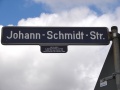
| Straßenschild Johann-Schmidt-Straße mit Erläuterung |
- Straße
- Johann-Schmidt-Straße
- Stadtteil
- Billinganlage, Hard
- Geokoordinate
- 49° 28' 51.42" N, 10° 58' 6.17" E
Die Johann-Schmidt-Straße ist eine Straße in der Fürther Weststadt (statistischer Bezirk Billinganlage, umgangssprachlich "Hard").
Bilder
Straßenschild Johann-Schmidt-Straße mit Erläuterung
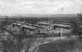
Kriegslazarett an der Bamberger Bahnlinie, Postkarte vom 26. April 1915. Im Hintergrund sind der Eichenhain und einzelne Gebäude der Villenkolonie zu erkennen.
